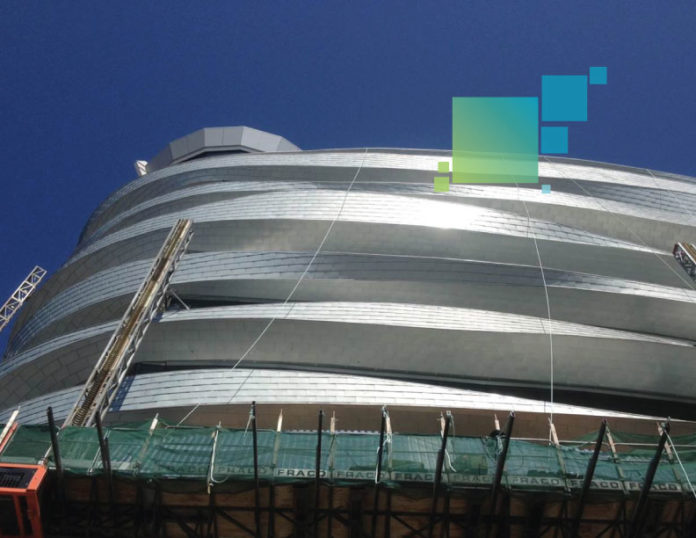
In 2011, Tronnes Surveys was asked to step in on a tricky project involving the Edmonton International Airport’s (EIA) new Combined Office Tower (COT), which integrates offices and the air traffic control tower in one eight-story building. A sleek, undulating zinc cladding system, meant to evoke Edmonton’s sweeping plains landscape, cocoons the COT and strikes a very modern, distinctive note. The trusses are all individually designed and mounted on hollow structural sections (HSS)—essentially 12,000 lineal feet of square tubing wrapped around the base structure, offset several inches by knife plates.It’s the crown jewel of EIA, but installing the COT’s cladding was a significant challenge for the surveyors and contractors who took on the task.
“Conventional surveying would have required the gathering of about 8,000 points on the outside of the building either with reflectorless technology or with lifts,” says Tronnes Surveys President Stephen Tronnes. “Mostly due to the access issues, neither option was very good. So we insisted on scanning the HSS.”
Early Identification of Variations Saves Rework
Tronnes Surveys was hired for the project by Thermal Systems KWC Ltd., the building envelope contractor and a regular client. Tronnes was actually brought in mid-project, when EIA accelerated building enclosure deadlines.
Thermal Systems also hired another subcontractor, Gehry Technologies, Inc., as an exterior fascia consultant. Gehry’s role was to design and oversee the fabrication of the intricate truss-based mounting system that would hold the zinc scales in place; done well, the cladding would achieve the designer’s graceful curvilinear vision. Done badly, it could be an awkward zinc mess.
Work began with the establishment of a solid 3D control network based on punch marks on steel barrier posts (bollards) and drill holes in the tarmac. To make setups on adjoining rooftops practical, “mud slabs” were used as tripod rests; this prevented damage to the roof membrane and stabilized the Leica ScanStation C10, which Tronnes used for the scanning work. Setups were always based on resections, with substantial overlap between scans so that registration could be used as a check on position.
Once control was established and setup issues were solved, the scan went relatively quickly. “In our first visit to the site, we completed the full scan of the seventh floor in eight setups that took less than half a day,” says HDS Specialist and Senior Project Manager Kent Nicholson. In just 11 days, the first dataset was delivered to Gehry Technologies.
Gehry’s analysis of the as-built dataset uncovered a problem that contractors and surveyors know well: substantial variations between the plan and the constructed building. In this case, the variations were both vertical and horizontal, with an important difference between the two. The vertical difference was small, just 13 mm (about half an inch), and consistent; a global adjustment to the site’s benchmark scheme resolved this issue to everyone’s satisfaction. But the horizontal variations were larger—more than 1 foot in some cases. They were inconsistent, and they seemed to be caused by installation discrepancies in main structural components. This was contentious; had Gehry Technologies used plan dimensions for truss design, the rework costs would have been astronomical.
Nicholson says that laser scanning really proved its worth in this instance. “Likely, without scanning, we wouldn’t have known that the main structure was not built exactly to design because of the building’s unique, non-regular shape. And individual points in a conventional survey would have been questioned endlessly. But with the point cloud available, we were able to produce any measurements needed to make our case. Scanning was the best solution given the constraints, and in light of the variations revealed by our as-built survey.”
Scanning Leads to Perfect-Fit Cladding
Having detected plan variations with scanning, and having worked through the edge extraction issues, the actual layout of truss locations was relatively straightforward. Tronnes crews were able to do the work in just nine days. “We found that the designed truss locations, which were extracted from our model and centered on the HSS rails, fit very well,” says Nicholson. “We were able to set out all truss locations from just three setups, and the layout points deviated from actual centers by 0-15 mm (0-0.6 inches).”
Using Tronnes’ solid dataset, Gehry designed nearly 1,000 trusses and had them fabricated offsite. They were produced in just seven days—much less time than would have been required by onsite fabrication—and during installation, only one truss had to be field fitted.
That’s extraordinary success for this type of cladding work, and it made a difference in the final appearance of the tower building. “The incorporation of scanned, as-built steel data into our digital design environment allowed us to perfectly calibrate our trusses to existing site conditions,” says Gehry Consultant Brendan Sullivan. “Without this step in the process, the smooth curvature of the final ribbon (cladding) surfaces would not have been achieved.”


