


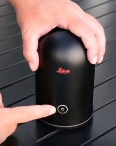
Laser scanning a historic structure is the fastest way to capture accurate measurements for documentation and restoration, but what is the best tool for this purpose? Chad Studer of NOAR Technologies, based in Troy, MI, recently tested the Leica BLK360 imaging laser scanner inside the Fillmore Detroit and achieved impressive results. “What stood out to me the most was the ease of use,” he said. “It was really simple, and I was able to quickly capture the entire project in color.”
Fast Scanning, Instant Results
Built in 1925, the Fillmore Detroit is a 12-story multi-use entertainment venue that houses an elegant theater with three levels of seating. Stately columns, ornate chandeliers and elaborate terra cotta decorations grace the interior of the Italian Renaissance structure.
 In less than 12 hours, Studer captured the entire interior of the Fillmore in full color and intensity using approximately 120 setups with the BLK360. At each setup, a single button push simultaneously captured spherical imagery and measurement data to create a rich 3D point cloud. This information was used to create a floorplan analysis showing the ground floor, mezzanine and balcony levels. “The BLK360 is incredible out-of-the-box technology,” Studer said. “You can instantly see results using Autodesk ReCap and pull the data directly into your design software. You go to the field and come back, and it’s done.”
Comprehensive, Accurate 3D Documentation
Studer, who also has extensive experience using the Leica ScanStation P-series professional laser scanners, said he would continue to recommend the survey-grade scanners for large-area scans and any applications that require survey quality across longer distances with guaranteed results. The dual-axis compensators in the larger scanners play an important role in keeping the scanner level and compensating for movement that would otherwise distort the resulting point clouds. However, in smaller areas that require accurate 3D documentation of real-world conditions, the BLK360 offers a simple solution.
“If you were going to use a tape measure, it’s a no-brainer to use the BLK360,” he said. “The tape measure is going to give you the same measurements, but this is going to be much more comprehensive, way more accurate and a lot faster.
“The saying used to be ‘measure twice, cut once,’” he added. “Now we can scan once and measure as many times as we want without going back to the site.”
Watch the video below for a flythrough of the data as well as the floorplan analysis. To learn more about the BLK360, visit https://lasers.leica-geosystems.com/blk360.


