Time is money in construction, and mechanical, electrical and plumbing (MEP) systems make up a large and critical piece of building costs and operations. With the increased attention on energy use globally, MEP contractors are under great pressure to design, fabricate and install their systems — which make up 25% to 40% of total construction costs — not only with the utmost accuracy, but also efficiency.
A proven way to improve competitiveness and profitability is with laser scanners. In a 2023 Leica Geosystems/Construction Dive survey of leaders at large MEP engineering and contracting firms, 71% of respondents report using 3D reality capture technologies on at least a monthly basis, if not more frequently. In fact, only one out of the 150 respondents said their company does not use laser scanners.
“With a laser scanner, you are capturing every surface of everything that is within its range and line of sight and getting millions of measurements within seconds.”
The appeal of these cutting-edge surveying, positioning and scanning tools is clear. Using light detection and ranging (LIDAR) technology, laser scanners can help project teams work up to 10 times faster over manual methods, according to an estimate by Atlantic Constructors MEP project manager Sunday Omodan in the report accompanying the Leica Geosystems/Construction Dive survey. With the detailed data collected by laser scanners and processed into a point cloud, a digital representation of the scanned environment, MEP contractors can develop a building information model (BIM) with the confidence that their ensuing work will be based on accurately documented site conditions.
“Traditional methods can provide a few dozen measurements in an hour or more,” says Ted Moberg, building construction product marketing manager at Leica Geosystems. “With a laser scanner, you are capturing every surface of everything that is within its range and line of sight and getting millions of measurements within a few minutes and even seconds.” The comprehensive scans reduce the likelihood of missing a critical measurement and costly site returns and rework.
Access Accurate Models Up to 70% Faster
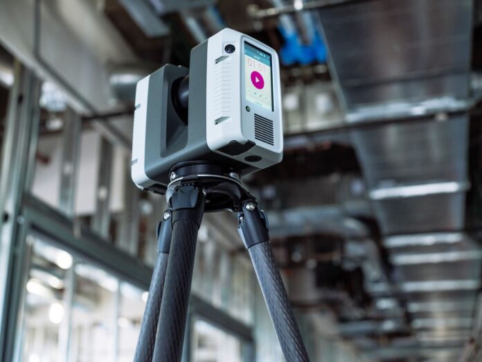
Laser scanners used for MEP work come in three general formats. A terrestrial laser scanner sits on a tripod mount and must be moved to multiple positions to document a space from different viewpoints. Handheld mobile scanners use simultaneous localization and mapping (SLAM) to track their own location during the site walkthrough. Autonomous scanners mount on a drone or robot and can survey a site with minimal to no human interaction.
A typical range that a scanner can see is 550 millimeters to 1 kilometer away, Moberg says. Depending on the device type and desired deliverable, accuracy can vary from fractions of a millimeter to a few centimeters. The scan resolution will also vary. “With mobile or SLAM devices,” Moberg says, “the speed at which the device is moving will increase or decrease the amount of data captured.”
After processing the scan data, often through software developed by the scanner manufacturer, an MEP professional now has a point cloud in hand, which maps the millions of data points captured onto a 3D coordinate system. With high-performance point cloud software such as Leica’s Cyclone product suite and Hexagon’s Reality Cloud Studio, a project team can view, manage and navigate through the virtual construction site and obtain locations and dimensions using any of the points.
A project team can also import the point cloud into BIM software and translate the scanned surfaces into BIM elements, components and objects to create a 3D model that accurately represents the existing site. Leica’s CloudWorx, for example, allows users to open their scanned data directly in the CAD or BIM program of their choice. They might also use automation or AI-powered tools, such as PointFuse powered by JetStream, to deliver highly optimized models up to 70% faster than traditional methods.
Put Your Digital Twin to Work
Once a BIM is classified, MEP professionals have many opportunities for using the BIM model to improve workflows, accuracy and the following:
- Conduct cost estimates and material takeoffs.
- Create and view model sections and details.
- Pull dimensions for fabricators and installers.
- Check code compliance.
- Check construction compliance and progress.
“We have tools that can do a comparison of the design versus what is getting built to provide the percent complete to accurately pay subcontractors,” Moberg says. “They can determine if what is installed meets tolerance. This data can also be shared with the design team to make incremental changes during construction to create a true as-built model.”
To select from the array of commercial software products, Moberg recommends a project team assess the cost per square foot of their current surveying and modeling process: “Make sure the software has the tools that best fit what you are trying to accomplish.”
To explore laser scanning and modeling solutions and discuss your needs with a building construction specialist, contact us.


