


It was an ordinary day on the job. Construction on the small restaurant building in Harrison, Ohio was progressing smoothly; the concrete foundation had been poured, and the plumbing pipes had been installed below the slab. Pete Lyness and his team from Maxwell Construction Co., based in Greendale, IN, wanted to capture some quick as-built documentation while the trenches were still open and the piping was exposed, just to validate that everything was in the right place. Using their Leica BLK360 imaging laser scanner, the team captured a few quick scans in about 30 minutes before wrapping up for the day and returning to the office.
Lyness is glad they took the time—and had the reality capture technology to provide fast, easy documentation. “We pulled the point cloud file right into AutoCAD and overlaid it on the drawings we had been given for the building,” Lyness said. “Very quickly, within an hour or two, we discovered that three of the plumbing pipes were in the wrong place. We were able to move those before the concrete slab was poured, which prevented rework later.”
Substantially More Information in Half the Time
Although the cost savings on the restaurant project was relatively small—Lyness puts the estimate around $1,500-$2,000—having an imaging laser scanner has provided substantial savings for the company in other ways. “We do a lot of remodels as well as renovations of historical buildings, and some of our projects are two or three hours away from our office,” he said. “Being able to scan the space and capture complete documentation prevents return trips to the jobsite. We’re able to record 10 times the amount of information in half the time compared to manual methods. The benefits of that are huge.”
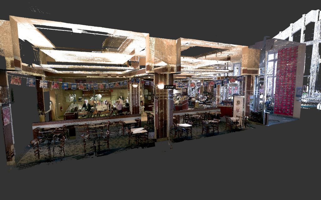
If the team misses any information while onsite, they simply pull the point cloud into AutoCAD, slice through it, and find the data they need. Having the additional detail also benefits their clients and subcontractors. Lyness cited one example where the company was asked to capture as-built documentation on a first-floor restaurant in a building in downtown Cincinnati that had experienced water damage. After the team returned to the office, the client requested electrical drawings. “We had all that information,” Lyness said. “I was able to locate the lighting and outlets because we had the scan; we didn’t need to return to the site.”
Reality Capture Designed for Design-Build Work
Lyness first began experimenting with point clouds several years ago, using photogrammetry captured from a drone. After attending the SPAR3D conference in Houston in 2016 and learning about laser scanning, he knew the technology would benefit his company. However, none of the laser scanners available at the time seemed to fit his needs. “As design-build contractors, we weren’t looking for the millimeter-level accuracy of the professional scanners,” he said. “We just need 20 to 30 scans in an existing building for as-built documentation to come within plus or minus 2 inches.”
On the other end of the spectrum, the smaller scanners he saw at the conference didn’t provide enough quality to justify the cost, and the workflows were too complex.
When he read about the BLK360 in an email from SPAR3D later that year, Lyness was intrigued. “It was in the price range we were looking for and it was from a reputable company,” he said. “We immediately signed up for it.”
Scanning Accurately and Easily for Better As-Builts
Although high accuracy wasn’t on his wish list, that was one of the first things he appreciated about the BLK360 when he started doing scans. The measurements extracted from the resulting point cloud are accurate to within 6 millimeters at 10 meters, or about 30 feet, making it ideal for the indoor documentation often handled by Lyness and his team. “We did one full building scan in less than four hours that gave us a lot of information to hand off to the subcontractors,” he said. “They still made site visits, but having that information in almost a virtual walkthrough and being able to actually measure from the point cloud was invaluable.”
The ability to quickly capture scans with a single button push and pull them into Autodesk software with little or no processing is another benefit. The simple workflow makes it easy for Maxwell Construction to integrate point clouds into their projects—which, in turn, drives productivity and quality.
“Being able to scan our projects brings a new level of professionalism to our work,” Lyness said. “It increases our ability to construct the building as designed.”


