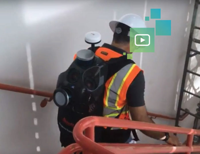
For thousands of years, the basic surveying and measuring principles used in construction and architecture have remained largely unchanged. Typically, they involve some sort of physical measuring device and a method of recording the distances. What has advanced dramatically are the tools used to take the measurements. Numerous options are now available, from physical tape measures, to digital laser tapes, to laser scanners.
As the construction industry increasingly implements digital processes, companies require more and more raw data collected in the field and on site. The faster this data can be collected and processed, the faster it can be used to make critical decisions. Despite the rapid evolution of technology, the industry has struggled with the ability to quickly, easily and accurately use reality capture technology to gather data in both interior and exterior construction applications, especially those that involve navigating difficult terrain or flights of stairs. This data is needed not only for new projects, but also for renovations and additions that have incomplete, inaccurate or missing as-built plans, and even post construction for facility management.
Fast, Comprehensive Building Documentation
The answer to these demanding requirements for speed and versatility is the Leica Pegasus:Backpack. Fast, accurate, and capable of interior, exterior and even underground data capture, the Pegasus:Backpack is a complete portable mobile mapping solution unique to the industry. Its capabilities come from two LIDAR sensors that capture accurate spatial data, and from an array of five cameras that work seamlessly together at a speed of 100,000sf <40 min, to create a spherical image. Operators simply don the device like a traditional backpack and walk through any environment they wish to map, making this capture method flexible and easy to use.
The Pegasus:Backpack uses simultaneous localization and mapping (SLAM) technology. This takes visual data from the camera feeds to create a point cloud map of the environment that computers can process and understand, similar to the technology utilized in self-driving cars. SLAM tech also uses location data taken from satellite GNSS networks to record location, bearing, distance, and time. This essentially enables the user to accurately capture comprehensive data on a site by simply walking through it, making progressive professional BIM documentation a reality.
RELATED: HOW BACKPACK MAPPING TRANSFORMS BIM DOCUMENTATION
Powerful Visualization Capabilities
On the post-processing side, the processed point cloud and image data can be used in typical AEC design software like Autodesk ReCap, AutoCAD or Revit. Pegasus datasets can also be used in the proprietary Pegasus:WebViewer, a software suite specifically designed to complement and enhance the backpack’s capabilities. This software allows the user to digitally retrace the same path as the recorded data and click on an image or location on the screen to bring up that exact spot in the point cloud. This symbiosis of visual user interface and powerful scanning technology allows for both quick navigation in large datasets and ease of use by all project stakeholders, regardless of their experience with point clouds.
The Right Tool for the Job
While static laser scanners can provide a dataset that is higher in accuracy, capturing the same complex areas that the backpack is capable of would be considerably more time consuming, both in setup and post-processing. Additionally, not every job requires the submillimeter precision that can be achieved with a full static scan. Conversely, more traditional methods such as tape measures and photo documentation lack the accuracy and completeness that is required in today’s digital construction environment. Choosing the right tool for the job at hand is critical in delivering datasets that strike the balance between speed and accuracy.
The Pegasus:Backpack empowers architects, contractors and owners in their appraisal and planning work by giving them new levels of data that can be implemented easily into their existing workflows. As they say, knowledge is power, and being able to perform large scale, comprehensive reality capture at this level of speed and accuracy provides an entirely new level of knowledge. It is, in a word, a game-changer.


